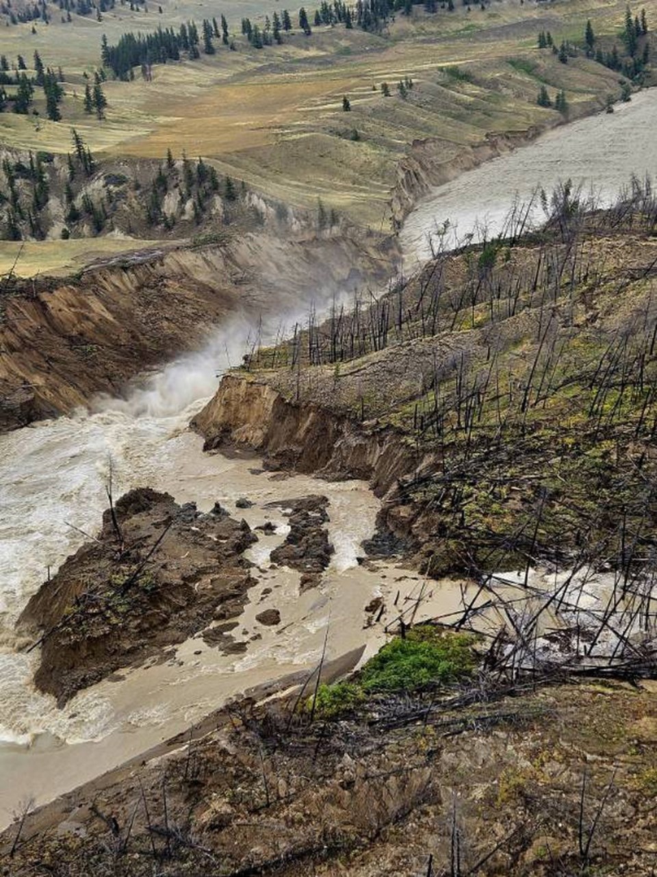
WILLIAMS LAKE, B.C. — Plans to help migrating salmon make it up British Columbia's Chilcotin River to spawning grounds are in the works after a massive landslide breach created barrier challenges, but officials will wait to see if the water carves a new route for the fish, says Nathan Cullen, the provincial water, land and resource stewardship minister.
Cullen said Thursday that the breach created a new "choke point" on the river that could impede sockeye salmon movement upstream, but the fish are extremely resilient and face many challenges on their journey to spawning grounds.
The government's plan to help salmon if needed comes as central Interior First Nations say they are measuring the impacts of the landslide that blocked the Chilcotin River for days, followed by a breach of the dam and a subsequent torrent of water that sent trees and debris downstream.
Cullen said at a news conference that the narrow spot on the river seems to be eroding, but doesn't seem to be at a point where the fish can pass.
"We have a little bit of time, but Mother Nature and salmon are incredibly resilient and it may resolve itself as the water gets cleaner as that blockage starts to diminish."
He said government officials are working with area First Nations and others in "preparing, essentially a plan B."
A massive rock slide in 2019 on the Fraser River at Big Bar, downstream from the Chilcotin River, saw officials catch and transport salmon past the site to continue their migration.
The Williams Lake First Nation said Thursday some heritage village sites that date back 4,000 years were swept away as the Chilcotin River carved at riverbanks, while the Tsilhqot'in National Government said critical salmon migration routes were seriously damaged and the threat of more slides exists.
The landslide south of Williams Lake that dammed the Chilcotin River last week broke free on Monday, sending raging water, trees and debris downstream to the Fraser River, which flows through the Lower Mainland to Georgia Strait.
Two heritage sites located along the banks of the Chilcotin River near the Farwell Canyon Bridge and a third site downstream at the confluence of the Chilcotin and Fraser rivers sustained extensive damage, the Williams Lake First Nation said in a statement.
"We are grateful that the landslide release has not caused catastrophic damage, but we are deeply saddened by the potential loss of irreplaceable Secwepemc history," said the statement.
The statement came after an aerial tour of the landslide and flood area by Williams Lake Chief Willie Sellars.
"We remain hopeful that once the situation stabilizes, valuable Secwepemc artifacts, stories, and insights will still be uncovered," it said.
Chief Joe Alphonse, the Tsilhqot'in National Government tribal chair, said damage assessments are still underway, but there are serious concerns about the impact the churning water had on spawning channels for migrating salmon.
With the valuable sockeye salmon run expected to reach the Chilcotin River in the coming days, it appears the landslide and rushing water created difficult new obstacles for the fish on their way to spawning areas, he said in an interview Thursday.
"For salmon passage, it's going to be a little worrisome," said Alphonse.
"It's not completely blocked," Alphonse said of the pinch point. "It's probably a four- or five-foot jump they'll have to get through. The amount of pressure shooting through there and the elevation is pretty steep."
Sellars said documenting and preserving the historic sites along the river will be addressed when the area is safe to return to, but the immediate priority is helping the salmon.
"It has to be acted on in short order," he said in an interview. "We will do everything we can to collaborate and make sure we do have fish for our future generations and we do have fish four years after when these fish are returning."
Earlier this week, the Tsilhqot'in launched an emergency salmon task force to call on all levels of government, including U.S. states, to take measures to preserve the sockeye and chinook stocks.
Alphonse called on the Fisheries Department to introduce "automatic" sport and commercial fishing restrictions to protect Chilcotin River and Chilko Lake salmon.
The Fisheries Department said in a statement Tuesday that based on historical timing it believes the majority of adult chinook salmon returning to the Chilcotin River this season migrated past the slide site before last week's landslide.
It also said most of adult sockeye are expected to arrive at the confluence of the Chilcotin and Fraser rivers around the third week in August, and coho not until the early fall.
The Fisheries Department was not immediately available Thursday for comment on the salmon runs.
Alphonse said it also appears much of the Chilcotin's riverbank area at the Farwell Canyon remains unstable and heavy rains could trigger another landslide.
Downstream communities along the Fraser River at Lillooet, Lytton and Boston Bar reported higher water levels similar to those of spring runoff after the water released, along with the presence of logs and debris.
There have been no reports of flooding.
Connie Chapman, B.C. water management branch executive director, said Thursday that flows on the Chilcotin River have returned to pre-landslide conditions but the water still contains high sediment levels.
Bank stability along the Chilcotin also remains a concern and tree debris is still being reported in the Chilcotin and Fraser rivers.
She said it was estimated thatthe volume of debris the flowed through the Chilcotin and Fraser rivers was about 60,000 cubic metres, with about 30,000 cubic metres being caught in a trap zone at Agassiz.
— By Dirk Meissner in Victoria
This report by The Canadian Press was first published Aug. 8, 2024.
The Canadian Press


